
Dr. Clark Alexander Skidaway Institute of Oceanograpphy
Presentation to Skidaway Hamiltons October 16, 2018
Sea Level Rise on the Georgia Coast
Dr. Alexander said that sea levels have varied hugely over time. Prior to the Ice Age 20,000 years ago, the coastline was as much as 90 miles inland from its current location. During the Ice Age when sea levels were at their lowest, the coastline was some 70-80 miles east of the current location. We need to care deeply because of our gently sloping coastal plane. A small change in sea level can have a huge effect on the Georgia coast. Anticipating changes is hugely important in planning where critical installations are placed. We need to be thinking ahead 50 to 100 years.
Two thirds of the sea rise occurring today is due to ice melting. One third of the sea rise is due to oceanic temperature rise. As the water gets warmer, it expands.
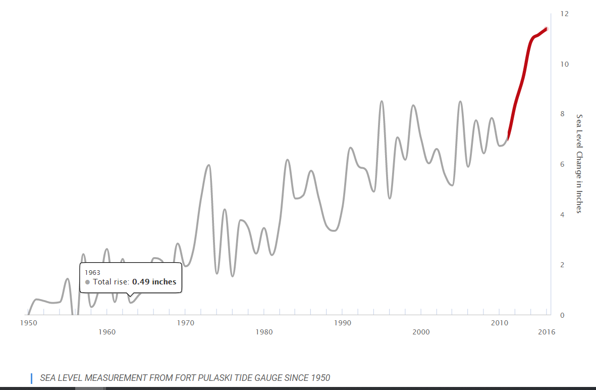
Dr. Alexander showed various tools used to view and measure sea rise. Research can be found at the Institute’s website under “Resources”. He showed satellite imagery of absolute sea rise. He also showed a measure of relative sea rise. It shows the effect of extraction by humans. For example, there are areas in Colorado where pumping of water from aquifers has caused the land to collapse. In some areas, sea levels are actually falling. In some cases this is due to plate tectonics. Some climate change deny-ers point to data showing sea level falls in some places as evidence that climate change is a hoax. We should not be distracted by such claims. In low latitudes, sea level has been rising one or two feet per century. In high latitudes, sea levels may be falling due to changes in the land. In the Southeast, all charts show a gentle, consistent rise in sea level of about 3.2 mm/year.
Dr Alexander talked about models that scientists use to forecast sea level rises. He made the point that all models are “wrong,” but some are useful. They are wrong because they are always incomplete. Examination of the data leads scientists to modify the models to make them better. Dating back to the mid-1970’s, scientists included atmosphere, land surface, and ocean and sea ice in their models. In subsequent periods, scientists have added aerosols, carbon cycle, dynamic vegetation, atmospheric chemistry, and land ice to their models. The models have always been conservative in their estimates of sea level rise. (See the IPCC Climate Change 2014 report on the Internet). Most models show 3-4 feet change in global sea level by the end of the century. Some models forecast a 6 foot change.
The Federal Government already uses sea level rise thresholds in their planning. The Department of Defense definitely looks at sea level rise in its planning and concludes that sea level rise impact on coastal military installations presents serious risks to military readiness, operations, and strategy. (See Sea Level Rise and the US Military Mission, published by The Center for Climate and Security). It is ironic that government agencies are alarmed while the Administration continues to deny.
What issues will we face locally as sea level rises:
Salt water intrusion into shallow coastal aquifers. Dr. Alexander showed pictures of dead trees in the marsh that use to be on hammocks fed by coastal aquifers.
Salt water will be pumped into wells. The water table will rise. Septic systems will become less efficient. Storm drains will be increasingly full of salt water and will be less effective.
There will be increased storm damage and more frequent flooding. Dr Alexander showed projections of flooding on the road to Tybee. At current sea levels, there are about 12 flooding events a year. With a sea level rise of 1.6 feet, there will be nearly 400 flooding events (200 days with tides twice a day). The road will have to be raised. To raise the road, it will also have to be widened which has environmental implications. While the city of Tybee has been proactive in facing the sea level rise issue, there is no stomach for spending the kind of money that would be needed to raise the road.
There will be increased erosion and loss of beach. We will armor our coasts. As sea levels rise, the salt marsh will move on to the upland and eventually into the canopy. If we put structures up to prevent erosion, the salt marsh will be under water and disappear. One solution would be to acquire land which is not inhabited were we can allow salt marsh to grow.
Using laser data from airplanes, we have a very good mapping of elevations on Skidaway Island. One can see the maps and the sea level rise under various assumptions at coast.noaa.gov ???.
The various models show rising sea levels with more rapid change occurring in the 2020’s and 2030’s. We will see direct evidence at that time if models are correct.
